

Document Library
On this page you can view all of our project documents.
To view our full application for development consent, visit the Planning Inspectorate website here.
Documents that were published prior to the submission of our DCO application can be found at the bottom of the page.
Guide to the approach on design
We’ve produced a guide that explains how to read the documents that show how we’ve developed and evolved the design of Norwich to Tilbury.
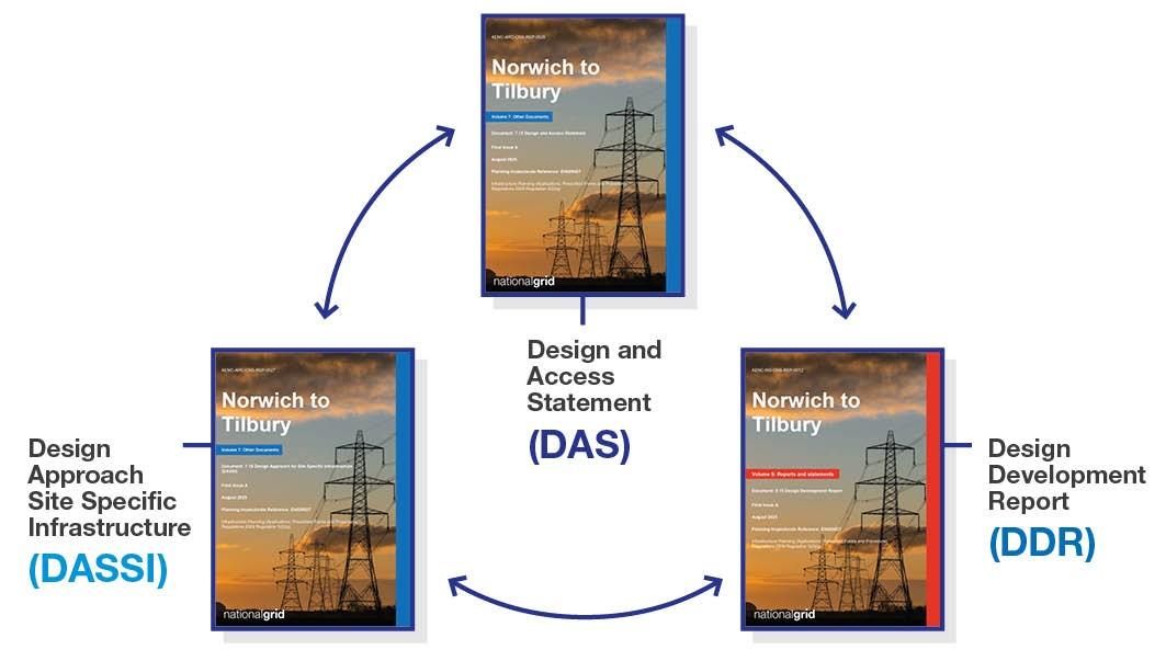
There are three main documents that explain our approach. They are:
- DAS – Design and Access Statement (document reference 7.15)
- DDR – Design Development Report (document reference 5.15)
- DASSI – Design Approach Site Specific Infrastructure (document reference 7.16)
These documents are available in the document library below and they can also be viewed alongside the rest of the documents we submitted as a part of our DCO application on the Planning Inspectorate’s website.
Document library
Document archive
Project Updates
Targeted consultation documents
Norfolk targeted consultations
Suffolk targeted consultations
Essex targeted consultations
Thurrock targeted consultations
Statutory consultation 2024 documents
Statutory consultation 2024 plans
| Project Background Document 2024 | Provides an overview of the project, detailing our proposals and how we are consulting. |
| Strategic Options Backcheck and Review 2024 | This summarises the method we’ve been using to evaluate our strategic choices. We regularly review and backcheck these methods as we continue to assess and make decisions about our strategic options. |
| Maps of our proposals 2024 | Showing the proposed route of our project. |
| Design Development Report 2024 | An in-depth technical document detailing the work we have undertaken to date, focusing on the work since previous consultations. |
| 2023 Non-statutory consultation Feedback Report | Summarises the feedback we received during the 2023 consultation and how it has been considered. |
| Community Newsletter April 2024 | An update on the progress of the project. |
| Consultation Feedback Form 2024 | To gather consultation comments and feedback. |
| Preliminary Environmental Information report non-technical summary | This document is the Non-Technical Summary of the Preliminary Environmental Information Report (PEIR). The PEIR provides the preliminary findings of the Environmental Impact Assessment (EIA) process. |
| Preliminary Environmental Information report | This document presents the preliminary findings of the Environmental Impact Assessment (EIA) process for the Norwich – Tilbury project. |
| Statement of community consultation | Sets out our proposed approach to consultation for the Norwich – Tilbury project. |
Summer 2023 consultation plans and documents
Summer 2023 consultation plans
Spring 2022 consultation documents
Landowner publications
Further information can be found on our Information for Landowners page.
If you feel your land may be affected by these proposals, please contact the Norwich to Tilbury Land Team at Fisher German by emailing [email protected] or by calling 0808 175 331.