




Our proposals
Weston Marsh to East Leicestershire is a proposal to upgrade the high-voltage electricity transmission network in Leicestershire, Lincolnshire and Northamptonshire.
The project includes:
- a new overhead line of approximately 60 km between Lincolnshire and Leicestershire
- two new substations would be built along the route: WMEL-A near Corby Glen in Lincolnshire and WMEL-B near Wartnaby in Leicestershire
- upgrades to around 66 km of existing overhead line between WMEL-B and Grendon Substation in Northamptonshire.
This proposal will help us deliver more secure, cleaner, home-grown energy from more affordable sources to where it is needed across the region.
What we’ve changed since Stage 1
Feedback from our Stage 1 Consultation, together with further technical and environmental work, has helped refine our proposals. We have used this information to develop our updated plans.
You may notice some changes to the way our consultation materials look and are presented. These updates reflect changes introduced through the Government’s Planning and Infrastructure Act 2025. For more information, please see our Stage 2 Consultation Strategy.
Our proposals in your area
We have broken down the route into five sections based on local authority boundaries. In our consultation materials each section has a colour, so you can easily find information about the proposals near you.
Route Section 1: South Holland
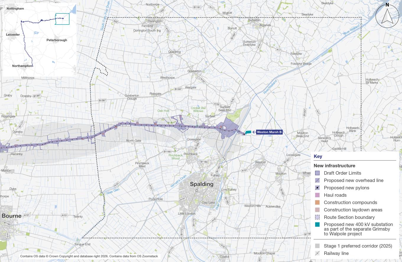
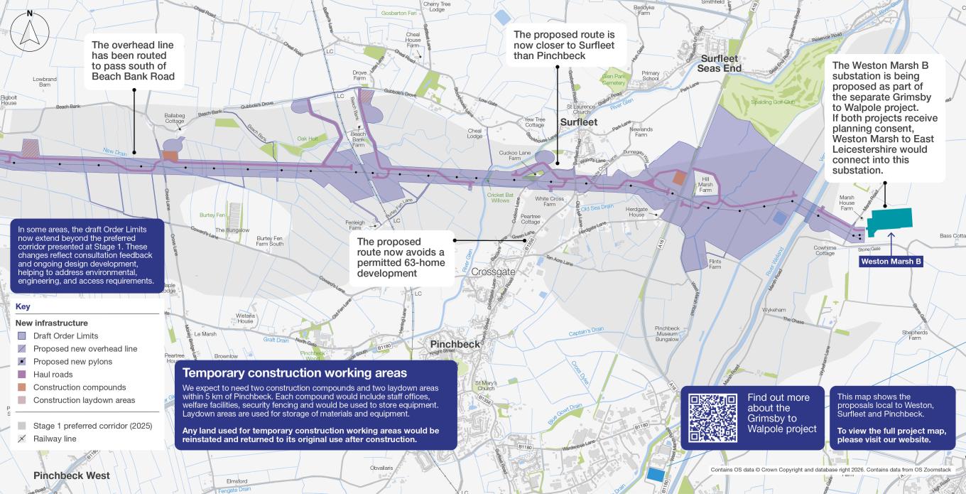
Route Section 1 runs from Weston Marsh B substation, located between Weston and Surfleet, to South Forty Foot Drain. Weston Marsh B substation is proposed as part of the separate Grimsby to Walpole project.
In this section, we are proposing around 11 km of new 400 kV overhead line supported by steel lattice pylons. Permanent works would also include access for inspection and maintenance, drainage works, environmental enhancements and any other infrastructure needed to operate the overhead line.
The route passes through open Fenland countryside, shaped by farmland, drainage channels and scattered belts of trees. Nearby communities include Weston, Surfleet and Pinchbeck. It also crosses several important watercourses, including the River Welland, River Glen and Vernatt’s Drain.
For more information about how our proposals have developed in this area, please see the Weston, Surfleet, Pinchbeck and surrouding areas leaflet.
Route Section 2: South Kesteven
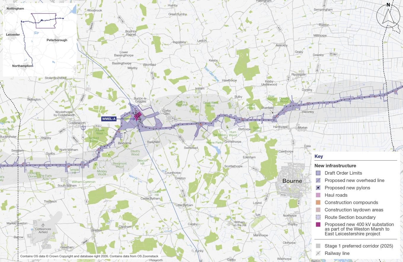
Route Section 2 runs from South Forty Foot Drain in the east, through South Kesteven, to the boundary with Melton in the west. The route in this section includes the proposed WMEL-A substation near Corby Glen.
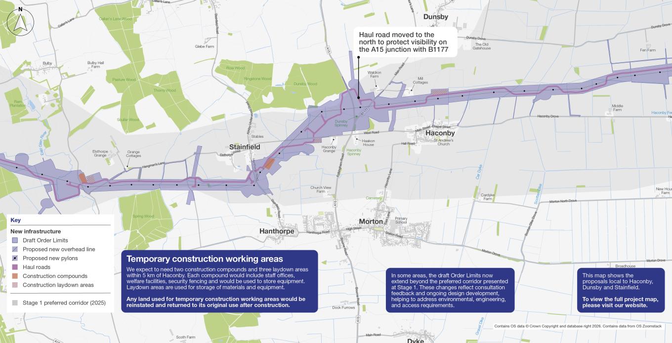
This section extends across a diverse landscape, connecting the open Fenland farmland in the east with the more rolling, wooded countryside further west. Nearby communities include Dunsby, Haconby, Stainfield, Corby Glen and Burton-le-Coggles. The route also crosses several major roads, railways and watercourses, including the A15, A151, A1 and the East Coast Main Line.
In this section, we are proposing around 31 km of new 400 kV overhead line supported by steel lattice pylons, along with the proposed WMEL-A substation near Corby Glen (see page 21 for more information). Permanent works would also include access for inspection and maintenance, drainage works, environmental enhancements and any other infrastructure needed to operate the overhead line and substation.
For more information about how our proposals have developed in this area, please see the Haconby, Dunsby, Stainfield and surrounding areas leaflet and the Corby Glen, Burton-le-Coggles, Swayfield and surrounding areas leaflet.
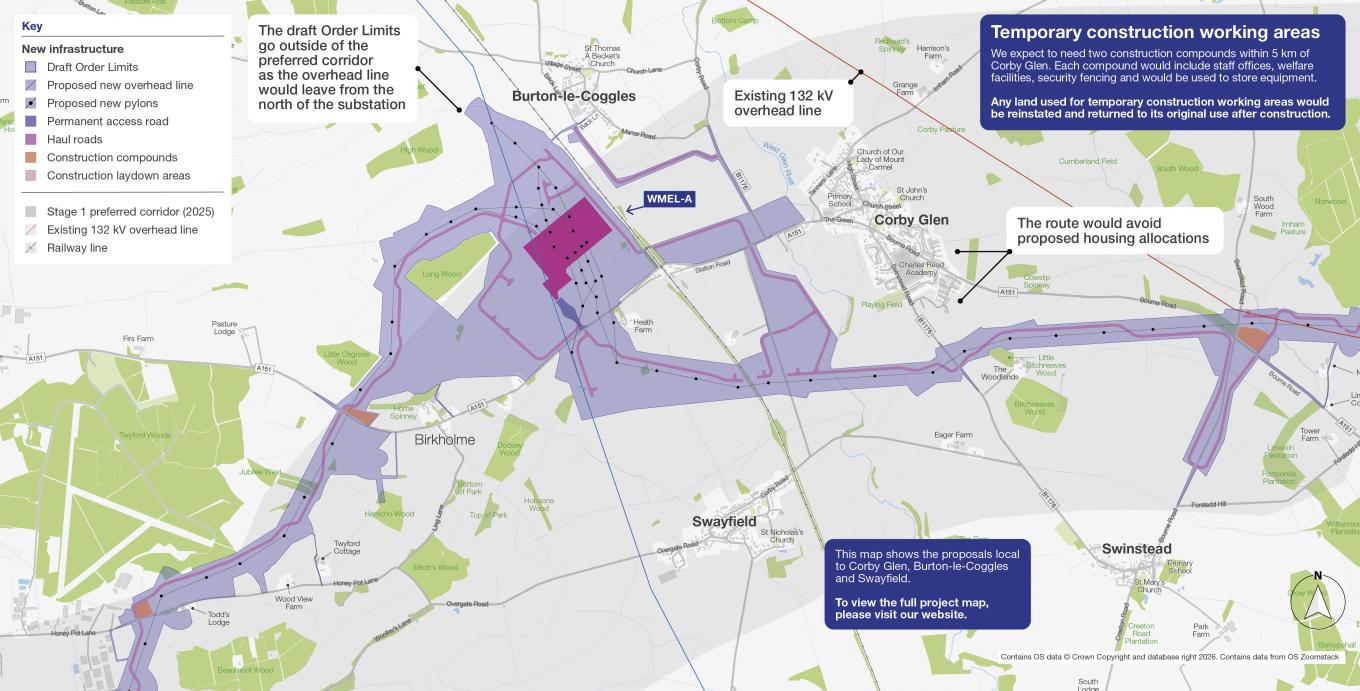
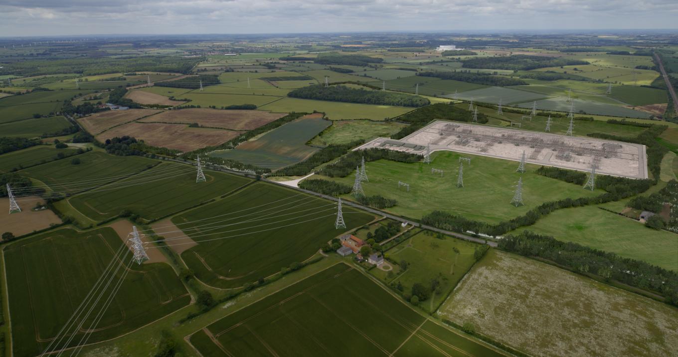
WMEL-A substation
The proposed WMEL-A substation would be a new 400 kV substation located to the west of Corby Glen, close to the East Coast Main Line. It would connect the new overhead line to the existing electricity transmission network.
The substation site would cover around 16 hectares. Most buildings and equipment would be up to 12.5 metres high, although some gantries would be taller at around 17 metres. A new permanent access road would connect the site to the A151 Station Road. Other supporting features would include areas for car parking and equipment storage.
You can read more about this in the Corby Glen, Burton-le-Coggles, Swayfield and surrounding areas leaflet.
Route Section 3: Melton
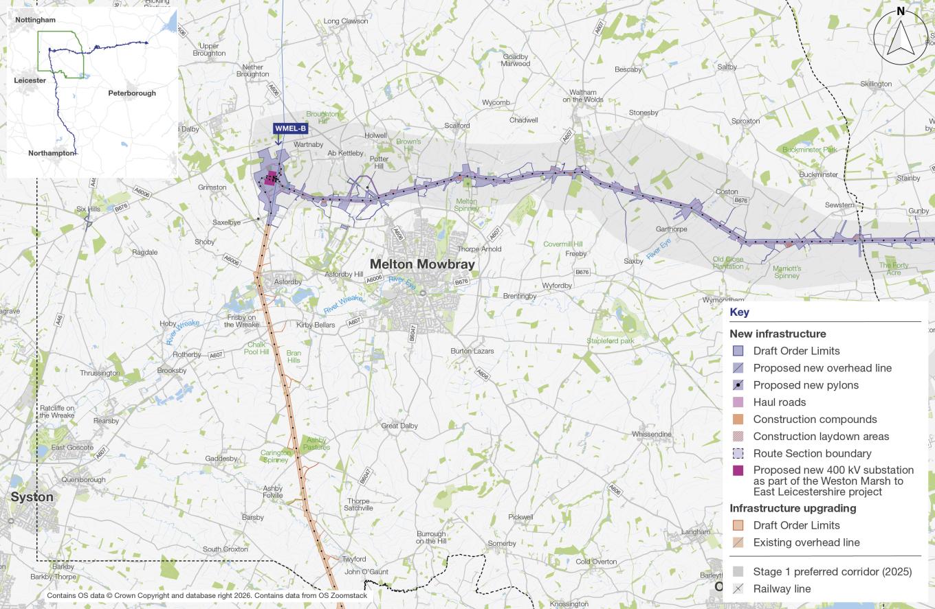
The section of the new overhead line begins east of Sewstern and continues west to the proposed WMEL-B substation, south west of Wartnaby.
Rolling countryside, woodland and small villages define much of this section. Nearby communities include Sewstern, Garthorpe, Coston, Ab Kettleby, Wartnaby, Saxelbye and Ashby Folville. The section also crosses local roads, watercourses and Public Rights of Way.
In this section, we are proposing around 20 km of new 400 kV overhead line supported by steel lattice pylons, along with the proposed WMEL-B substation. Permanent works would also include access for inspection and maintenance, drainage works, environmental enhancements and any other infrastructure needed to operate the overhead line and substation.
We are also proposing to upgrade around 14 km of the existing 400 kV overhead line between WMEL-B and Twyford. These works would increase the capacity of the line in this area.
For more information about how our proposals have devloped in this area, please see the Ab Kettleby, Wartnaby and surrounding areas leaflet.
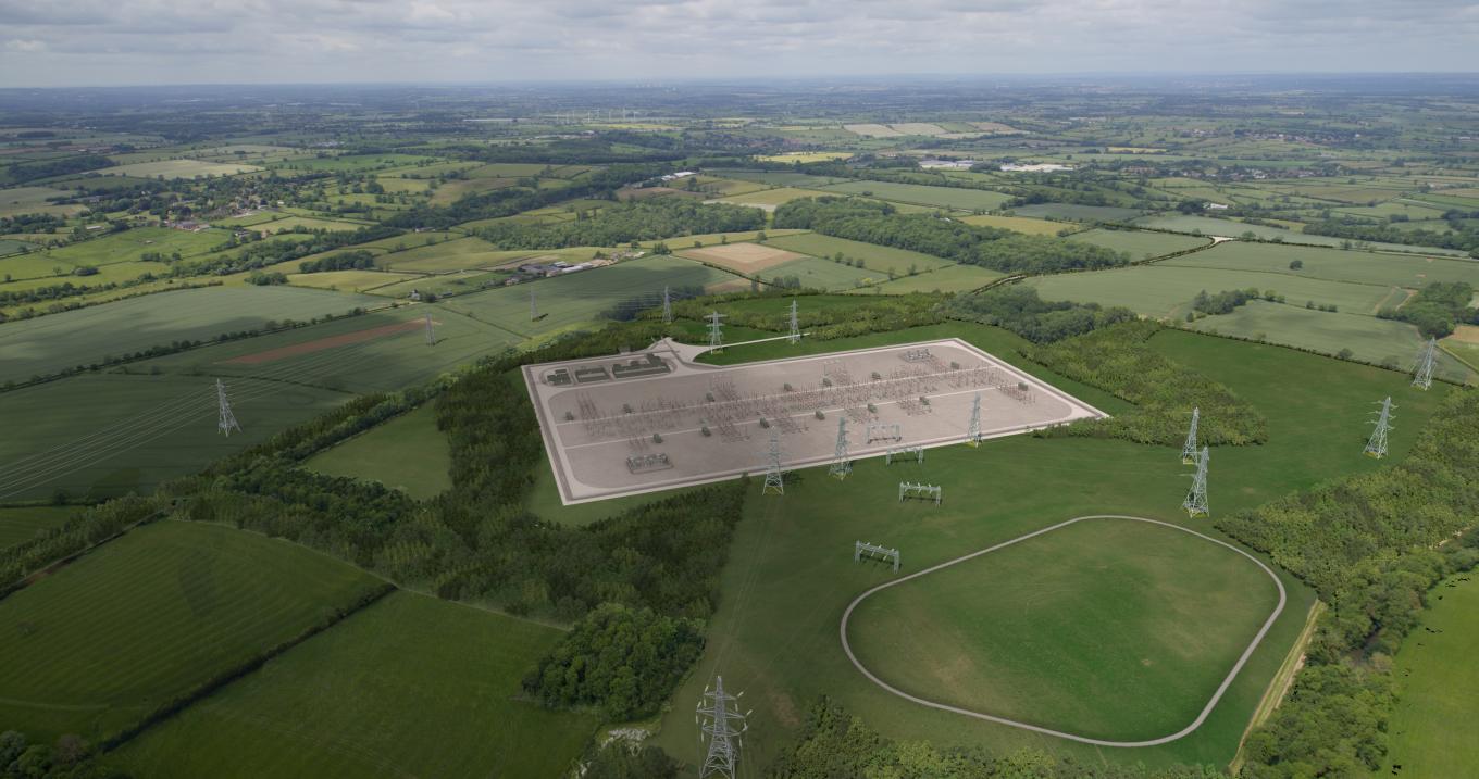
WMEL-B substation
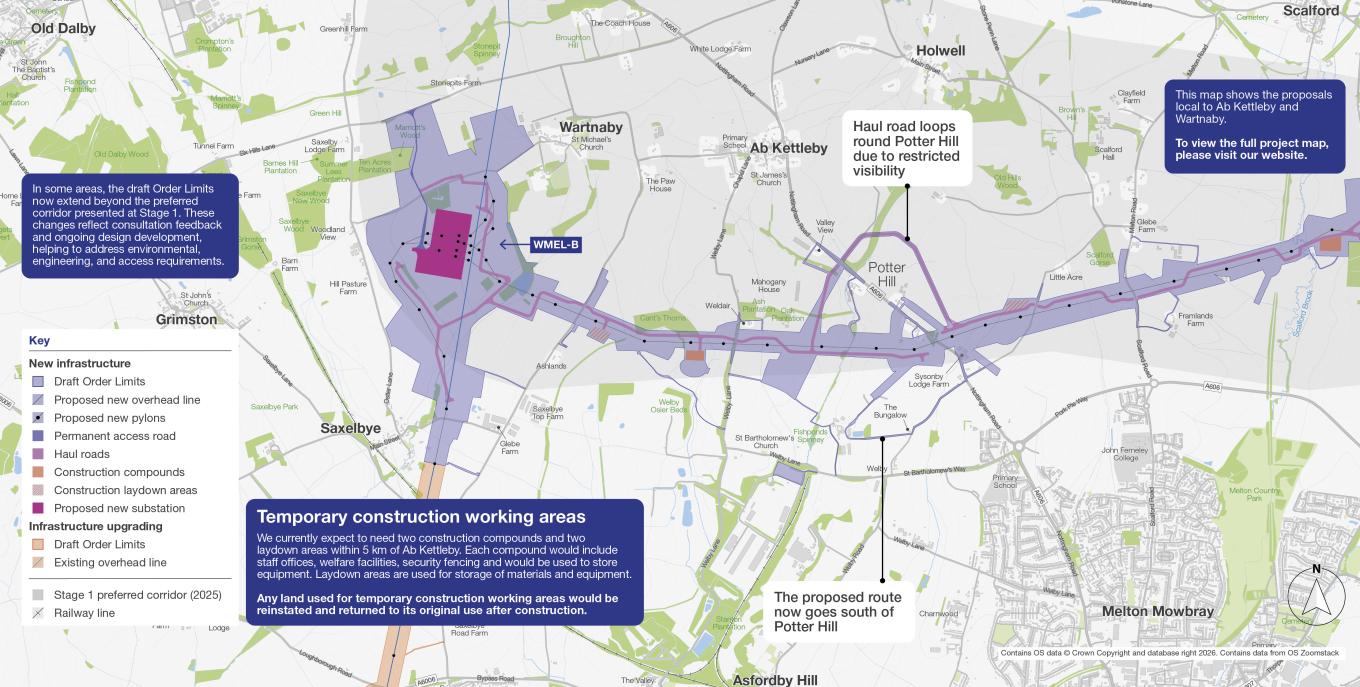
The proposed WMEL-B substation would be a new 400 kV substation located south west of Wartnaby and north-west of Melton Mowbray. It would connect the new overhead line to the existing electricity transmission network.
The substation site would cover around 12.6 hectares. Most buildings and equipment would be up to 12.5 metres high, although some gantries would be taller at around 17 metres.
The plans also include changes to the existing overhead line so it can connect to the new substation. A new permanent access road, approximately 1 km long, would connect the site to Six Hills Lane.
Other supporting features would include a drainage pond to help manage rainwater, along with areas for car parking and equipment storage.
You can read more about this in the Ab Kettleby, Wartnaby and surrounding areas leaflet.
Route Section 4: Harborough
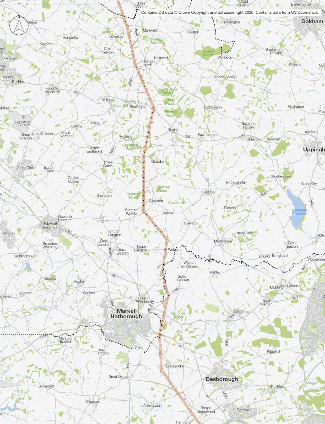
In Route Section 4, we are proposing to upgrade 19 km of existing overhead line from south of Twyford to south-west of Welham, where Langton Brook meets the River Welland.
The aim is to increase the amount of electricity the line can carry, without introducing a new overhead line route through this section.
Route Section 5: Northamptonshire
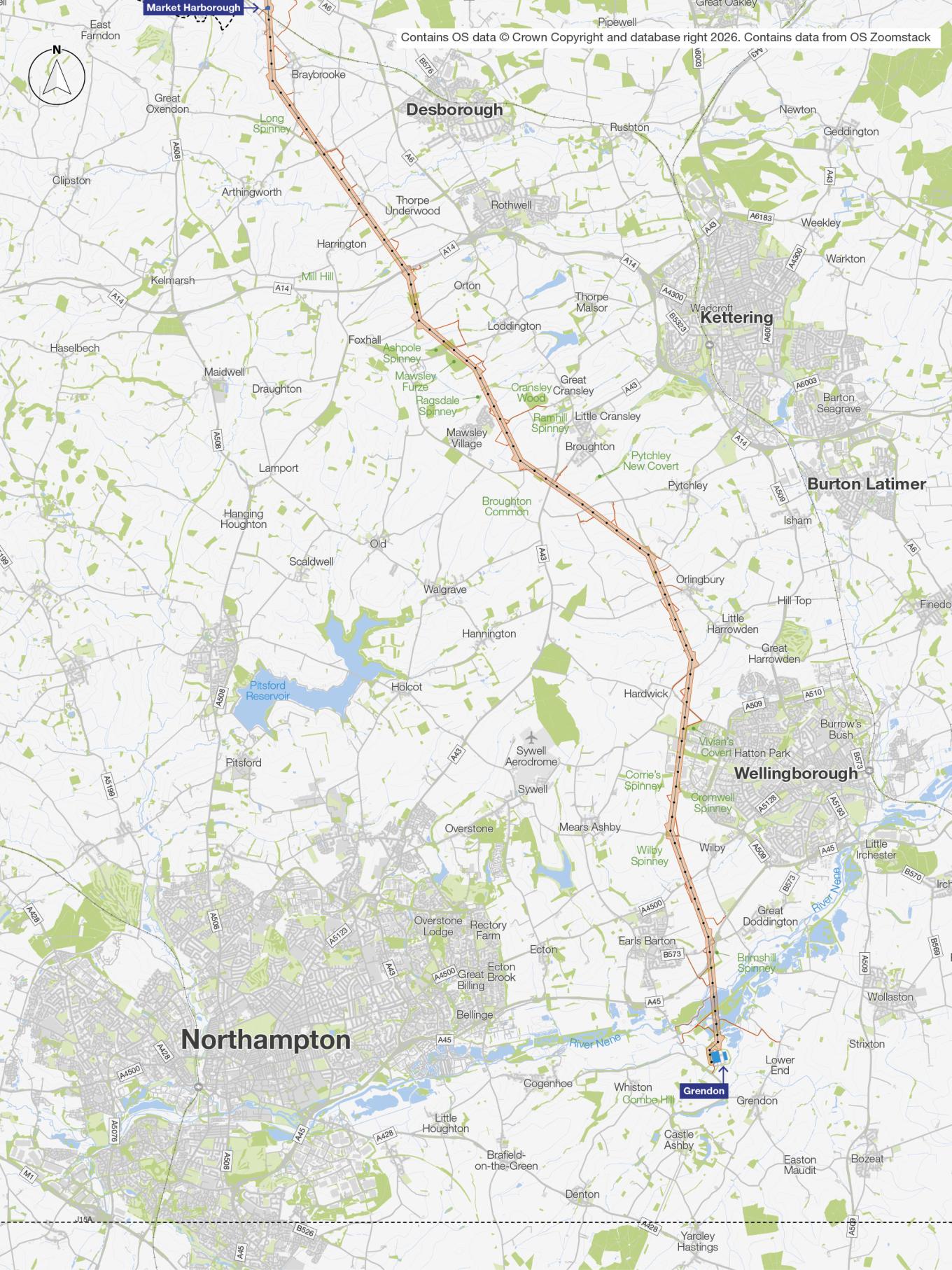
In Route Section 5, we would continue upgrading 34 km of existing overhead line through North Northamptonshire and West Northamptonshire. This section runs from near where Langton Brook meets the River Welland, south-west of Welham, towards the existing Grendon 400 kV substation.
Upgrading the overhead line
As part of this project, we are proposing to upgrade approximately 66 km of the existing overhead line from the proposed WMEL-B substation near Wartnaby in Leicestershire down to the existing Grendon substation in Northamptonshire.
This would help strengthen the electricity network in this area and increase the amount of power it can carry, while making use of existing infrastructure wherever possible.
We will always upgrade existing infrastructure where we can – reducing the need for new overhead lines.
Maintaining and improving existing overhead lines is an important part of managing the electricity transmission network. We carry out similar upgrades across the country to help keep electricity flowing safely and reliably.
The proposed work would include replacing the wires between pylons and upgrading some fittings. The new wires can carry more electricity, helping us make better use of the existing network.
How we upgrade lines
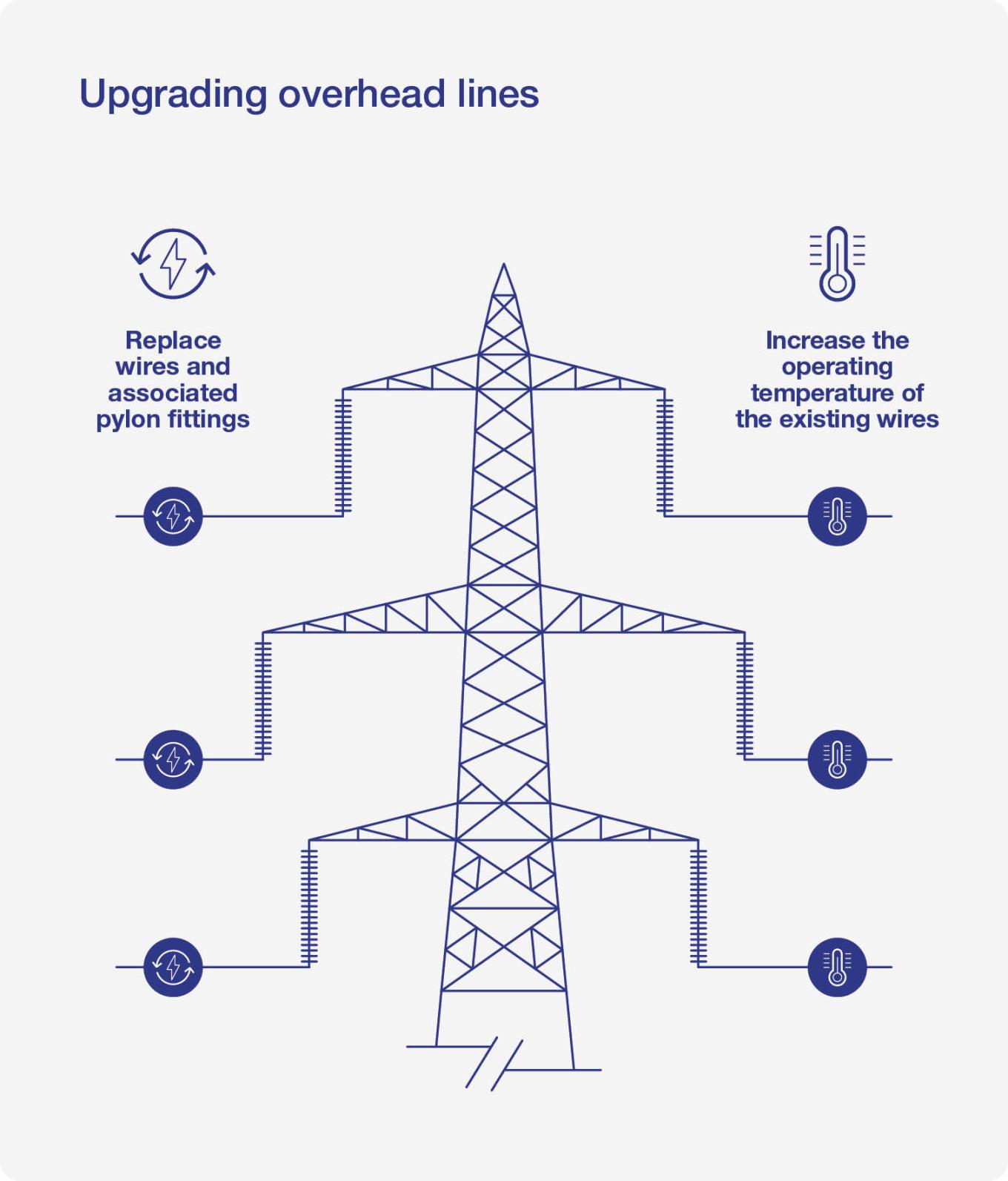
We are proposing two different types of upgrade, because the circuits on each side of the overhead line are different.
On one side of the overhead line, we would replace the existing wires and pylon fittings. This includes parts such as insulators, which separate the wires from the pylon. The new wires can operate at higher temperatures and more efficiently. This type of work is sometimes called reconductoring.
On the other side, we would retain the existing wires and increase their operating temperature.
Together, these improvements would increase the amount of electricity the wires can carry without replacing them and help meet future electricity demand.
Some work may also be needed at existing pylons to make sure the upgraded line continues to keep a safe distance from the ground, buildings and other features. This could include small changes to fittings or other equipment.
In a small number of locations, individual pylons may need to be replaced where this is necessary to support the upgraded line safely and reliably.
Surveys
We have started carrying out surveys in the area to better understand the local environment.
This is helping us to know more about local habitats, wildlife, watercourses and landscapes, and to identify ways to avoid or reduce impacts wherever possible.
You might also notice teams undertaking surveys at the pylons along the route. They are looking at the condition of the pylons as well as their foundations.
If you have received a letter requesting access to your land, it’s so we can complete surveys as part of the planned upgrade to the existing overhead line.
This does not mean we are planning to build any new infrastructure on your land.
If you have a question about access to your land, please contact our Lands team at Savills by:
- Email: [email protected]
- Freephone: 0800 567 7600
- Post: Freepost WMEL Land (no stamp or further details needed).