

Our proposals
This page presents our proposals for Grimsby to Walpole, fully updated with detailed plans following our Stage 2 consultation in summer 2025, and our Weston Marsh targeted consultation in winter 2025.
Our proposals for Grimsby to Walpole include:
- approximately 140 km of new 400 kV overhead transmission line
- a new 400 kV substation to be built in the vicinity of the existing Grimsby West 400 kV Substation in North East Lincolnshire (to be referred to as New Grimsby West Substation). The existing substation would be decommissioned, in full, or part. The extent of decommissioning will be determined and reported in the Environmental Statement
- two new 400 kV Lincolnshire Connection substations located south-west of Mablethorpe in East Lindsey (to be referred to as Lincolnshire Connection Substation A and Lincolnshire Connection Substation B)
- two new 400 kV substations located in Weston Marsh (referred to as Weston Marsh Substation A and Weston Marsh Substation B), as well as a new 400 kV underground cable connecting the two substations
- a new 400 kV substation in proximity to the existing Walpole Substation west of the village of Walpole St Andrew and north of the town of Wisbech, in King’s Lynn and West Norfolk District (to be referred to as “Walpole B Substation”)
- replacement of short sections of existing 400 kV overhead line and local changes to the lower voltage distribution networks to facilitate the construction of the new overhead line and substations.
The Project will include other required works such as diversions for existing overhead lines, temporary access roads, highway improvements, work compounds, and ancillary works. It will also include utility diversions and drainage works. Land would also be required for mitigation and enhancement of the environment, to deliver an overall biodiversity net gain (BNG). BNG is an approach to development that leaves habitats in a better state than before.
We will carry out an Environmental impact assessment (EIA) and submit a full Environmental Statement and non-technical summary as part of our application for development consent.
You can view the proposals on our interactive map. To learn more about the detail of what is proposed in your area, please see the Stage 2 consultation document. For more detail about what is proposed in Route section 5, please see the Weston Marsh targeted consultation document. Both documents are available in the Document library.
Route Sections
You can use the Interactive map to zoom in and explore the route and associated infrastructure.
Our proposals for Grimsby to Walpole have been divided into the following Route Sections:
Learn more
Explore our interactive map and photomontages of the proposals.
The new Grimsby West Substation would be located immediately to the west of the existing National Grid Electricity Transmission substation, to the west of Wybers Wood. Once Grimsby West Substation has been constructed, the existing substation would be mostly, or entirely, decommissioned. The new substation would use Air Insulated Switchgear (AIS), meaning most of the equipment would be outdoors.
Click here to look at the detailed maps and plans, or watch the Route fly through videos below.
From the proposed new Grimsby West Substation, the route would cross the A46 between Laceby and Laceby Acres, pass between Barnoldby le Beck and Waltham, then run south towards Brigsley. It would then continue southeast, crossing the B1201 east of North Thoresby, and route west of Fulstow, Covenham St Bartholomew, Covenham St Mary, Yarburgh, and Alvingham, before crossing the Louth Canal east of Louth. The route then heads south, connecting to Lincolnshire Connection Substation-A.
Click here to look at the detailed maps and plans, or watch the Route fly through videos below.
Lincolnshire Connection Substation A is proposed to be located northwest of Alford, to the immediate east of Greenfield Wood and Mother Wood. Lincolnshire Connection Substation B is proposed to be located northeast of Bilsby. The two proposed 400 kV substations would be connected by an overhead line that routes southeast from Lincolnshire Connection Substation A and crosses the A1104 south of Saleby, before crossing the A1111 and connecting into Lincolnshire Connection Substation B.
Click here to look at the detailed maps and plans, or watch the Route fly through videos below.
From Lincolnshire Connection Substation B, northeast of Bilsby, the proposed overhead line would run south over the B1449, pass west of Cumberworth, and cross Sloothby High Lane east of Sloothby. It would then continue south towards the A158 Skegness Road, then west of Burgh le Marsh, crossing the Poacher railway line and Steeping River, before heading southwest past Midville, Gipsey Bridge, and Frithville, crossing the A16 to reach the Refined Weston Marsh Substation Siting Zone.
Click here to look at the detailed maps and plans, or watch the Route fly through videos below.
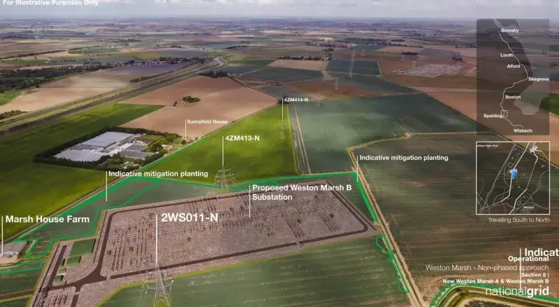
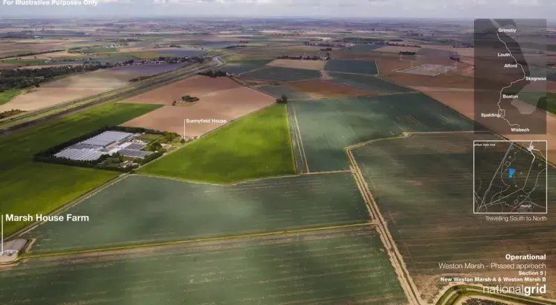
Weston Marsh Substation A site would cover around 10.6 hectares and be located north of Weston and just east of Marsh Road, near Surfleet Seas End. Weston Marsh Substation B site would cover around 8.4 hectares and be located north of Stone Gate and east of Marsh Road, near the Moulton Seas End junction. Both sites would be enclosed within a secure fence, and the tallest equipment would reach up to 12.5 metres, with overhead line gantries up to 15 metres high.
The proposals include new, existing and modified overhead power lines and towers to connect the new substations to the existing network and to proposals for Grimsby to Walpole. Weston Marsh Substation A would connect to Lincolnshire Connection Substation B to the north, Walpole B substation to the south, and to the existing electricity transmission network. Weston Marsh Substation B would connect to the existing electricity transmission network, and to Weston Marsh Substation A.
Visit the Document library to look at the detailed maps and plans, or watch the Route fly-through videos below.
Weston Marsh Substations A & B - Full Proposal (DCO) Fly Through
The proposed overhead line would head south from Weston Marsh, crossing the A151 west of Weston, then east, passing north of Weston Hills and Austendike. From Whaplode Fen, it routes southeast, passing north of Whaplode St Catherine and northeast of Holbeach St Johns, then southeast of Tydd St Giles and Newton-in-the-Isle. It would cross the River Nene before continuing east to connect to the new Walpole B substation, north of Walton Highway.
Click here to look at the detailed maps and plans, or watch the Route fly through videos below.
The proposed location for the substation would be to the north of Walton and immediately west of West Drove North, adjacent to the existing 400 kV overhead line. The substation would require us to reconfigure the existing overhead lines that currently connect to the existing 400 kV substation, enabling them to connect into the new substation.
Click here to look at the detailed maps and plans, or watch the Route fly through videos below.
Early Delivery at Weston Marsh
Our proposals for the DCO application from Grimsby to Walpole include both Weston Marsh Substation A and Weston Marsh Substation B. However, we are also seeking to build part of Weston Marsh Substation A earlier than the rest of Grimsby to Walpole.
In addition to our DCO application, we will also apply to South Holland District Council and the Department for Energy Security and Net Zero for planning permission for this initial phase of development.
What's happening next?
We are carefully considering all the feedback we have received from our Stage 2 and targeted consultation, alongside our ongoing technical and environmental studies. Our next steps include:
reviewing your feedback, as well as comments from local communities, stakeholders, and local authorities
continuing technical work, including surveys and assessments, to help shape the proposals
for the earlier phase of development at Weston Marsh, we will submit a planning application to South Holland District Council (under the Town and Country Planning Act), and an application under section 37 of the Electricity Act 1989 to the Department for Energy Security and Net Zero
for the wider Grimsby to Walpole project, we will submit an application for a Development Consent Order (DCO)
keeping you updated through our project website and by email newsletters if you have registered for updates.