

Our proposals
The key onshore and marine elements of our proposals in England and English waters are:
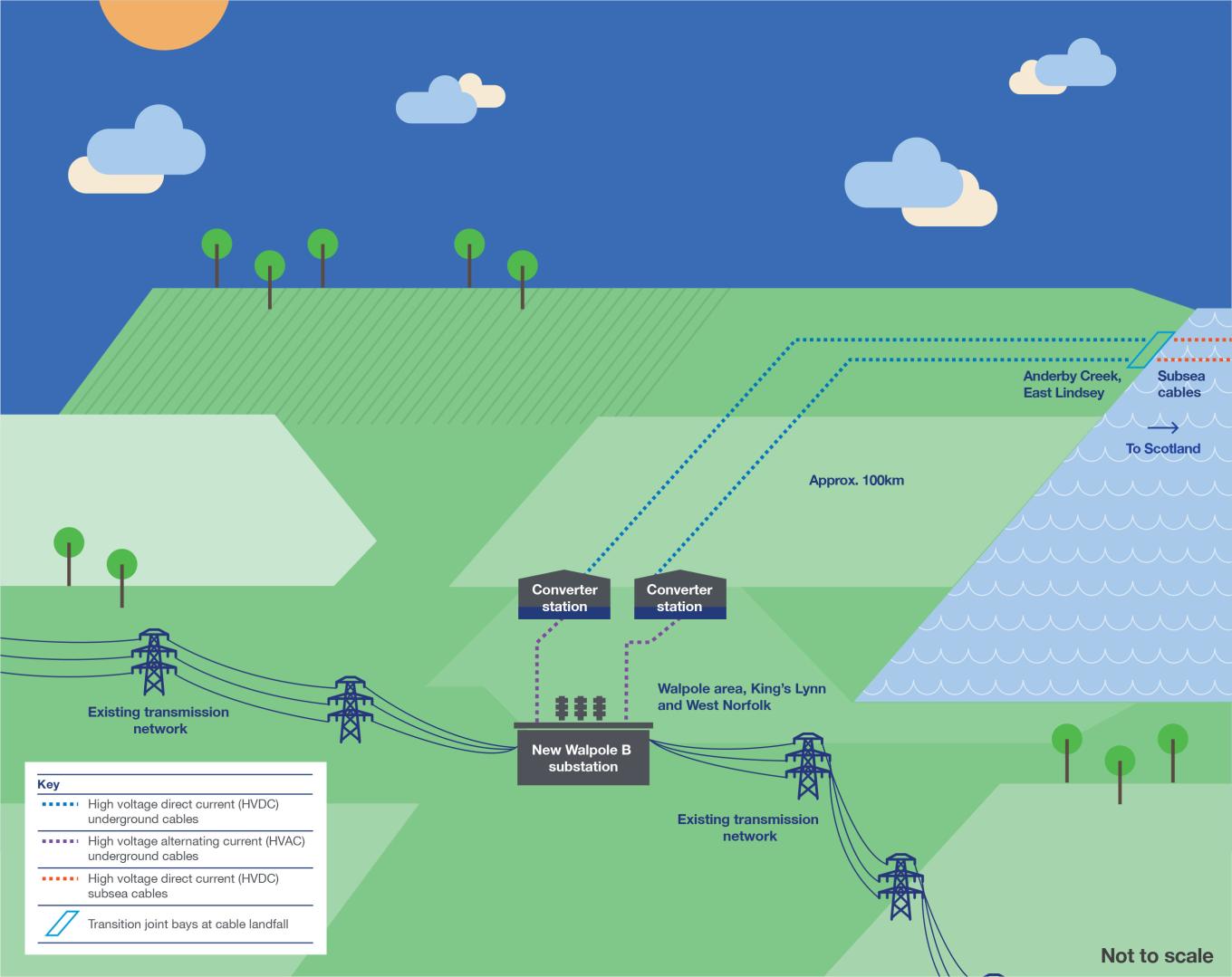
- Subsea high voltage direct current (HVDC) cables. In English waters, EGL 3's cable would be approximately 436 km long and EGL 4's would be approximately 425 km
- Transition joint bays to connect our subsea and onshore HVDC cables, located onshore near to our proposed cables landfall at Anderby Creek on the Lincolnshire coastline
- Underground HVDC cables running together for approximately 100 km from the joint landfall at Anderby Creek to the EGL 3 and EGL 4 converter stations in the Walpole area, West Norfolk
- Two converter stations in the Walpole area with one converter station for EGL 3 and one for EGL 4
- One substation in the Walpole area, called Walpole B, where both EGL 3 and EGL 4’s Walpole converter stations would connect to and then onto the electricity transmission network (this substation is also jointly proposed as part of NGET's Grimsby to Walpole project)
- Onshore underground high voltage alternating current (HVAC) cables that would connect the converter stations into the substation
- Supplementary works to the existing 400 kV overhead line to enable a connection with the new Walpole substation.
Sufficient land would be required to build EGL 3 and EGL 4 and to reduce the potential impacts of the projects, including:
- temporary land for construction activities including work areas for construction equipment and machinery, site offices, welfare, storage, access and drainage
- land required for mitigation, compensation and enhancement of the environment as a result of the environmental assessment process, and for the purposes of delivering biodiversity net gain, for example by landscaping and planting.
Since our Stage 2 consultation, we have identified some additional land that we would need to build the Projects to support construction activities and environmental mitigation. This land was not included in our Stage 2 consultation. We are therefore carrying out a targeted consultation on the proposed works within these additional areas. This will help to finalise our proposals.
Find out where our proposals would be located
You can view our onshore proposals from the second stage of consultation on our interactive map by following the link below.
To learn more about what’s being proposed in your area, please see our Document library. This includes all the materials we have published on the EGL 3 and EGL 4 projects, including the Stage 2 consultation document which provides more detail and information on our proposals.
EGL 3 and EGL 4 onshore in England
EGL 3 and EGL 4’s timeline
What’s happened so far?
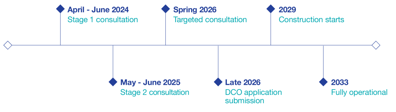
In spring 2024, we held our first stage of consultation on our early proposals for EGL 3 and EGL 4. Feedback from this consultation helped to develop our proposals.
During our second stage of consultation, held between May and June 2025, we presented and sought feedback on our detailed proposals for EGL 3 and EGL 4. This included where we proposed to build the new infrastructure and what we should consider as we further develop our proposals.
We have now reviewed all feedback received during Stage 2. Alongside ongoing technical and environmental assessments, the information we have gathered has further informed our plans.
This included identifying some additional land required to build the Projects. We therefore held a targeted consultation in Spring 2026 to gather feedback on the proposed works within this additional land.
What’s happening next?
We are currently working through all feedback received during our Spring 2026 targeted consultation and undertaking further surveys and environmental assessments.
This work will help to finalise our proposals. We intend to submit these as part of our Development Consent Order (DCO) application in late 2026.
During this time, we will also:
- continue our discussions with landowners and people with a legal interest in land
- continue working with local authorities and other stakeholders
- provide updates to those who have asked to be kept updated on our proposals via email. You can register for these updates here.